
March 25 - 26, 2011
A bit of early morning drizzle pattered down on my tent and knowing that I had enough time to do so, I stayed in my sleeping bag a little longer, with my head wrapped up in the fleece jacket I was using as both a pillow and a cover to keep out the chill of the cold nights, dropping down around freezing at that time of year. Slowly getting up and having a bit of granola breakfast from my pack of dry food, I got out and ready for my trek. The advantage of my new plan was that I could leave my large pack and tent behind for the first day, making a hike up the side valley and back down to the same spot for the evening. Bits of sun were breaking through the clouds, and I hoped that various predictions that it often rained during the night and stayed mostly dry during the day would prove to be true.
Hiking through a narrow U-shaped valley of grasslands, I left the campsite and headed North towards Grey Lake and Grey Glacier. Though this area is incredibly popular for hiking, that doesn't mean it's easy. Climbing up and down the undulating trail, I kept moving along, marvelling at the changing views. One of the best parts about the park is that the views change often, revealing magical bits of mountains, forests, glaciers, lakes and steep river valleys, or any combination thereof. Not long into the hike, I was alongside the long narrow Lake Grey, a darker lake with steep banks of rock and scrubby vegetation, populated with occasional small icebergs coming off the glacier at the top of the lake. As the sun shone down and I climbed up and down, I got hot in my jeans and t-shirt, though all it takes it a minute or two of standing on a windy cliffside with chilled air coming off the lake and glacier or down from the mountains to cool down quite quickly. My jacket came on and off, and I even held my gloves and woolly hat for most of the hike, since I was often putting them on or taking them off. To me, this was close to perfect hiking weather, not too hot or humid and cold enough to cool down quickly without being completely freezing, though I just hoped things didn't change.
Alongside the lake, a few steep climbs over rocks and roots led me to the top of a beautiful lookout point, catching my breath and having a snack as I peered over the water at the distant glacier, split into two by a large rock intrusion where the glacier reaches the ice cold water. With the lovely lake to my left, the scenery climbed steeply to my right, leading to the edge of the cluster of mountains crowning the middle of the park. This was quite an amazing start to the walk, and I was excited to see more and more, though halfway through the first day, I was already feeling a bit tired. I reached the glacier face and spent time at the lookout point just across the water from the sprawling mass of ice before heading down to the water's edge to check out a few clumps of ice that had drifted into a tiny bay and gotten stuck in that corner until the winds changed. My timing was also good, as I was able to avoid a group of hikers coming in just after me, particularly with one young American trekker who had already failed at endearing himself to us on the boat the day before, breaking out a few terrible tunes on a harmonica, presumably newly acquired judging by his skill level, and butchering the names of a group of French students with whom he was now hiking. As it turned out, I'd have the pleasure of seeing him over and over again during the long hikes, but the scenery was more than enough to make up for occasional run ins with him.
Coming back from the glacier, I made a quick stop at the Grey campsite to check things out, finding a pleasant, wooded site just near the edge of the lake. The site here is a lot quieter than the Paine Grande site where I was staying, but I was still happy that I didn't have to drag all of my gear up and down those hills all the way up there. As I went back, I crossed a few streams and a mini-gorge, feeling more and more exertion as my legs started to groan and an impending blister began to announce its presence on my toe. Again, this was more of an inconvenience, as the amazing landscapes here help draw your attention away from any physical impediments. I finally arrived back at the campsite late that afternoon, finishing off about 24 kilometers (15 miles) of hiking up and down on rocky terrain, happy to be back to rest my tired body. With it being my first day on the trail and helping to get accustomed to that much hiking, I was happy with my decision to leave my big bag behind and do the day trek, returning to the same spot for the evening. I also opted for the expensive dinner at the refuge, but I topped off my plate at the buffet style meal with a salad, bread, soup, dessert, meat and pasta, trying to at least make the $20 dinner worth it. Another cold and slightly rainy night followed, and I awoke a bit earlier to start my second day.
My legs and joints were a little sore from the constant pounding of the previous day, but I knew I had to keep moving, so I packed up my stuff and headed East over a small ridge and onto a mostly flat trail through a few tiny patches of forest and near the edge of Lake Nordenskjold. This portion of the trek takes you up to the base of the Cuernos, so despite walking almost directly into the fluttering sunlight, the views of the massive black and white striated, rocky peaks were enough to provide some inspiration. Around lunchtime, I arrived at the Italian camp (these sites are named for climbing expeditions by various groups, hence the nationalities), a beautiful spot at the base of Valle Frances/French Valley. Just before getting to the camp, a swinging bridge hangs over the small, fast flowing creek below, surrounded by large pebbles and bordered by thick green forest. Looking up the valley from the bridge, the sight was amazing, revealing a huge, slightly narrow valley with hanging glacier along one mountainside and the beautiful Cuernos and Torres on the other side. I contemplated taking an easy day and staying at the Italian campsite, as it was a very beautiful setting hidden in the trees, protected from the buffeting wind at nights and sitting alongside a picturesque waterway, so I dropped off my big bag in one of the quiet camping spots and headed up into the valley, choosing to decide when I came back.
The hike up to Valle Frances is predictably almost entirely uphill, as you hike from the edge of the lake up into the valley, more or less following the creek up to its source from the glaciers of the mountains. Sometimes muddy, I started off with fairly clear and dry weather, and I was in awe of the great views. To the left, the deep green forest was thick right up until the edge of the ice, presumably dropping an unseen flow of water careening down into the creek that runs down the spine of the valley, topped by mountains up to 3,000 meters tall (almost 10,000 feet). To the right, mangled trees and openings covered in huge rock slides alternate, all the while backed by the exposed rocky tips of the mountains, standing tall at around 2,700 meters (almost 9,000 feet). Moving up into the valley, I could see dark clouds coming in over the tips of the mountains, foreboding some bad bits of weather to come. Just as I reached the top of the 2 hour climb and near the British camp, I caught a quick view of the amphitheater of mountains closing in the back of the U-shaped ring, though the clouds soon obscured the views, bringing in strong winds and a quick, light snowstorm, though nothing too significant. Deciding to keep moving with the impending weather, I hurried back down, taking shelter in the trees as the rain came down off and on, though never quite hard enough to convince me to put the waterproof pants on over my jeans (basically the opposite of waterproof pants for hiking). Back down at the bottom of the valley, I still liked the look of the lovely campsite, but I still had a little over two hours of daylight, which is almost exactly what I'd need to make it to the next stop, the Cuernos refuge.
The hike was the Italian camp to the Cuernos refuge was luckily not nearly as hilly as some other parts, mostly skirting along the edge of the large Lake Nordenskjold. I ended up walking with a group of three girls for part of the hike, one of whom I had met at a communal pizza restaurant back in Puerto Natales featuring one large picnic table for the guests. Though I was tired, I was glad to keep moving on, meaning that I'd be that much closer to my destination the next day. I had originally thought I'd take an easy day and make the next day a lot longer, but this would help even out things a bit. We passed through more dense forest and even walked along the edge of the lake, climbing up and down onto the black and white pebbled beaches of the lake shore, a beautiful site with the steep mountains standing just behind us, though huge winds carrying sprays of water kept coming off the lake, so it's not a place where you'd want to linger too long. I got to the campsite again just before dusk, finding a sheltered spot amongst some high grasses and low trees, as this is a very windy spot, something that can be quite loud and annoying as you try to sleep while the nylon flaps of the tent buffet throughout the night. Just as I was getting everything ready in my dark tent, I felt a creature's presence in their with me, feeling like a bug or something hopped around just behind me. I grabbed my flashlight and searched around the small tent and under my bags, finally seeing a scurrying mouse running around, trying to escape. Apparently I had left the tent slightly open as I set it up, and it must have smelled my bag of food, as I found a small hole in the bottom of the bag and a little pile of granola where it had chewed through the cereal box while I was sitting in the lodge with my tiny dinner. I didn't particularly want to grab the mouse, and before I had a chance, it retreated into my open backpack, so I had to carefully pull out the items one by one until it was just the mouse trying to hide in the back of the bag. I picked up the bag and dropped the little guy outside the tent, hoping that he was my only resident as I tried to drift off to sleep. (In the morning, I heard a few other stories about mice roaming the campsites, though none actually inside tents like mine.)
My first two days of the strenuous W trek were finished, and though I was exhausted, I was loving it. At the end of the day, I had hiked about another 24 kilometers, basically the same as the first day, though more than half of that was done with my big pack of camping gear, clothes and food. The beautiful mix of mountains and lakes provide an ever-changing landscape of unbelievable splendor, and even though it's a popular route, I felt privileged to be able to experience this wonderful slice of nature. There were still two more days of long walking ahead of me, and I just hoped the weather would continue to turn out in my favor. I had experienced bits of rain, lots of wind and even a small passing snow, but all in all, I had been quite lucky in such a fickle environment.
 (Early morning on the first day of my trek on the epic W track, named for it's approximate shape. This is a small part of Lake Grey, fed from a huge glacier further up the valley. For the first day, I left my big bag at the Paine Grande lodge and hiked up and back to Glacier Grey. Hiking around 8 hours up and down hills, it's not easy, but the scenery made it all worth it.)
 (After a few hours of gusty winds and lots of hiking up and down hills, I made it to the lookout for Glacier Grey, a beautiful blue glacier melting away to create the huge lake on the side of the trail.)
 (Small coves in the lake harbor clumps of icebergs broken away from the glacier face. The trail mostly follows the edge of the lake (though sometimes high up some hillsides above), so you have many spectacular views of the area.)
 (The view from a lookout about halfway between Glacier Grey and the Paine Grande refuge. That's the glacier in the background, and the trail drops down the rocky mountainside here, following along in and out of forest.)
 (Coming back from the glacier, the sun came out for a while, though it continually changed. Hiking up and down all of the hills, I almost got hot, but it simply took a minute or two of standing still to cool down with the fresh air and wind blowing. I wore a jacket at first, but I kept having to take it on and off, so I ended up without it most of the time. For almost the entire trek, I hiked with my hat and gloves in hand, as I would take them on and off over and over again as I got hot or cold.)
 (After my first long day of trekking, I got back to the refuge and decided to splurge on an expensive dinner - about $20. I had hiked about 25 km/15 miles, so I felt like I deserved it. It wasn't exactly clear whether or not you could get more, so I loaded up my plate with pasta, meat, salad, soup, bread, juice and even some jello. Not too bad, really.)
 (For day two, I packed up my bags and headed off from Paine Grande down by the side of Lake Nordenskjold. This is the view of the looming mountains all around as you hike along the base of them.)
 (Moving across from Paine Grande to the French Valley was a fairly flat, though windy, hike, so that was a nice break, especially since I was carrying my heavy bag packed with food, tent, sleeping bag and a few bits of clothing.)
 (French Valley sits in the center of the park, a narrow valley between the two clusters of mountains, topped by glaciers. When the clouds clear off, it's a really beautiful place.)
 (The swinging bridge at the base of French Valley, leading directly to the Italian camp. These international names refer to the spots used by expedition teams when first climbing these mountains. I left my big bag at the ranger's office and headed up into the valley for a 4 hour hike, hoping the weather would stay calm.)
 (Trudging over a field of huge rocks and steeply ascending under the shadow of the mountains and glaciers, the trail then makes its way back towards some forest, with the side of the Cuernos above. The multicolored rock is a result of a magma intrusion from an ancient lava flow.)
 (I was still smiling as the clouds mostly stayed above the mountains, revealing this beautiful mix of streams, forest, rocks and ice. On the way down, I wasn't as lucky, as rain and wind came in, though it was never quite a downpour.)
 (Another typical view of magical French Valley.)
 (I was advised that the valley can get pretty muddy at times, but I was lucky to find it mostly dry, winding in and out of the forest.)
 (Near the top of the valley, you get bits of these strange, wind-blown trees. Just past this point, I got to the top of the valley, just in time to see a big storm and dark clouds coming in, covering an amphitheater of mountains that close in the back of the valley. The trees provided a nice refuge as the clouds dropped in, sheltering me first from the snow flurries and then from the stronger rain that flew by on the strong winds moving down the valley.)
 (One or two trees were just beginning to turn orange/red. I imagine this valley would be truly spectacular in early to mid April, though you might also get some pretty cold weather.)
 (One final view of the massive glacier hanging on the West side of the valley. I wasn't sure if I'd take an easy day and stay at the Italian camp for the night or move on, but I got back with about 3 hours of daylight left, so I ignored my tired legs and decided to push on to the next campsite, Los Cuernos refuge.)
 (Beautiful Lake Nordenskjold showing some of its blue/green color. The middle portions of the W Trek follow alongside this lake for long portions of the walk.)
 (Two small portions of the trek even walk along the pretty pebble beach. It provides a great view of the lake, but the strong winds coming off the water, carrying large mists of water from the tops of the waves provide good incentive to keep moving. You can see the gusts, white with water, coming across the lake, so I tried to hurry from one tree to another to provide a bit of shelter. If you're not ready for it, some of the gusts are strong enough to push you off the trail.)
 (Predictably, Los Cuernos refuge sits right underneath the peaks of the same name, providing some great views when the weather allows. The site is also known for having quite a few mice scavenging for food, and I even found one in my tent just before going to sleep, so I had to chase him around and empty out my backpack where he was hiding before trying to sleep and hoping that he was the only one to infiltrate my sleeping area.)
 (A final view just before darkness was setting in. French Valley lies beyond the first ridge on the right, and the Paine Grande refuge and Lake Grey are just beyond the second set of ridges in the background, where I had begun that morning.)
A bit of early morning drizzle pattered down on my tent and knowing that I had enough time to do so, I stayed in my sleeping bag a little longer, with my head wrapped up in the fleece jacket I was using as both a pillow and a cover to keep out the chill of the cold nights, dropping down around freezing at that time of year. Slowly getting up and having a bit of granola breakfast from my pack of dry food, I got out and ready for my trek. The advantage of my new plan was that I could leave my large pack and tent behind for the first day, making a hike up the side valley and back down to the same spot for the evening. Bits of sun were breaking through the clouds, and I hoped that various predictions that it often rained during the night and stayed mostly dry during the day would prove to be true.
Hiking through a narrow U-shaped valley of grasslands, I left the campsite and headed North towards Grey Lake and Grey Glacier. Though this area is incredibly popular for hiking, that doesn't mean it's easy. Climbing up and down the undulating trail, I kept moving along, marvelling at the changing views. One of the best parts about the park is that the views change often, revealing magical bits of mountains, forests, glaciers, lakes and steep river valleys, or any combination thereof. Not long into the hike, I was alongside the long narrow Lake Grey, a darker lake with steep banks of rock and scrubby vegetation, populated with occasional small icebergs coming off the glacier at the top of the lake. As the sun shone down and I climbed up and down, I got hot in my jeans and t-shirt, though all it takes it a minute or two of standing on a windy cliffside with chilled air coming off the lake and glacier or down from the mountains to cool down quite quickly. My jacket came on and off, and I even held my gloves and woolly hat for most of the hike, since I was often putting them on or taking them off. To me, this was close to perfect hiking weather, not too hot or humid and cold enough to cool down quickly without being completely freezing, though I just hoped things didn't change.
Alongside the lake, a few steep climbs over rocks and roots led me to the top of a beautiful lookout point, catching my breath and having a snack as I peered over the water at the distant glacier, split into two by a large rock intrusion where the glacier reaches the ice cold water. With the lovely lake to my left, the scenery climbed steeply to my right, leading to the edge of the cluster of mountains crowning the middle of the park. This was quite an amazing start to the walk, and I was excited to see more and more, though halfway through the first day, I was already feeling a bit tired. I reached the glacier face and spent time at the lookout point just across the water from the sprawling mass of ice before heading down to the water's edge to check out a few clumps of ice that had drifted into a tiny bay and gotten stuck in that corner until the winds changed. My timing was also good, as I was able to avoid a group of hikers coming in just after me, particularly with one young American trekker who had already failed at endearing himself to us on the boat the day before, breaking out a few terrible tunes on a harmonica, presumably newly acquired judging by his skill level, and butchering the names of a group of French students with whom he was now hiking. As it turned out, I'd have the pleasure of seeing him over and over again during the long hikes, but the scenery was more than enough to make up for occasional run ins with him.
Coming back from the glacier, I made a quick stop at the Grey campsite to check things out, finding a pleasant, wooded site just near the edge of the lake. The site here is a lot quieter than the Paine Grande site where I was staying, but I was still happy that I didn't have to drag all of my gear up and down those hills all the way up there. As I went back, I crossed a few streams and a mini-gorge, feeling more and more exertion as my legs started to groan and an impending blister began to announce its presence on my toe. Again, this was more of an inconvenience, as the amazing landscapes here help draw your attention away from any physical impediments. I finally arrived back at the campsite late that afternoon, finishing off about 24 kilometers (15 miles) of hiking up and down on rocky terrain, happy to be back to rest my tired body. With it being my first day on the trail and helping to get accustomed to that much hiking, I was happy with my decision to leave my big bag behind and do the day trek, returning to the same spot for the evening. I also opted for the expensive dinner at the refuge, but I topped off my plate at the buffet style meal with a salad, bread, soup, dessert, meat and pasta, trying to at least make the $20 dinner worth it. Another cold and slightly rainy night followed, and I awoke a bit earlier to start my second day.
My legs and joints were a little sore from the constant pounding of the previous day, but I knew I had to keep moving, so I packed up my stuff and headed East over a small ridge and onto a mostly flat trail through a few tiny patches of forest and near the edge of Lake Nordenskjold. This portion of the trek takes you up to the base of the Cuernos, so despite walking almost directly into the fluttering sunlight, the views of the massive black and white striated, rocky peaks were enough to provide some inspiration. Around lunchtime, I arrived at the Italian camp (these sites are named for climbing expeditions by various groups, hence the nationalities), a beautiful spot at the base of Valle Frances/French Valley. Just before getting to the camp, a swinging bridge hangs over the small, fast flowing creek below, surrounded by large pebbles and bordered by thick green forest. Looking up the valley from the bridge, the sight was amazing, revealing a huge, slightly narrow valley with hanging glacier along one mountainside and the beautiful Cuernos and Torres on the other side. I contemplated taking an easy day and staying at the Italian campsite, as it was a very beautiful setting hidden in the trees, protected from the buffeting wind at nights and sitting alongside a picturesque waterway, so I dropped off my big bag in one of the quiet camping spots and headed up into the valley, choosing to decide when I came back.
The hike up to Valle Frances is predictably almost entirely uphill, as you hike from the edge of the lake up into the valley, more or less following the creek up to its source from the glaciers of the mountains. Sometimes muddy, I started off with fairly clear and dry weather, and I was in awe of the great views. To the left, the deep green forest was thick right up until the edge of the ice, presumably dropping an unseen flow of water careening down into the creek that runs down the spine of the valley, topped by mountains up to 3,000 meters tall (almost 10,000 feet). To the right, mangled trees and openings covered in huge rock slides alternate, all the while backed by the exposed rocky tips of the mountains, standing tall at around 2,700 meters (almost 9,000 feet). Moving up into the valley, I could see dark clouds coming in over the tips of the mountains, foreboding some bad bits of weather to come. Just as I reached the top of the 2 hour climb and near the British camp, I caught a quick view of the amphitheater of mountains closing in the back of the U-shaped ring, though the clouds soon obscured the views, bringing in strong winds and a quick, light snowstorm, though nothing too significant. Deciding to keep moving with the impending weather, I hurried back down, taking shelter in the trees as the rain came down off and on, though never quite hard enough to convince me to put the waterproof pants on over my jeans (basically the opposite of waterproof pants for hiking). Back down at the bottom of the valley, I still liked the look of the lovely campsite, but I still had a little over two hours of daylight, which is almost exactly what I'd need to make it to the next stop, the Cuernos refuge.
The hike was the Italian camp to the Cuernos refuge was luckily not nearly as hilly as some other parts, mostly skirting along the edge of the large Lake Nordenskjold. I ended up walking with a group of three girls for part of the hike, one of whom I had met at a communal pizza restaurant back in Puerto Natales featuring one large picnic table for the guests. Though I was tired, I was glad to keep moving on, meaning that I'd be that much closer to my destination the next day. I had originally thought I'd take an easy day and make the next day a lot longer, but this would help even out things a bit. We passed through more dense forest and even walked along the edge of the lake, climbing up and down onto the black and white pebbled beaches of the lake shore, a beautiful site with the steep mountains standing just behind us, though huge winds carrying sprays of water kept coming off the lake, so it's not a place where you'd want to linger too long. I got to the campsite again just before dusk, finding a sheltered spot amongst some high grasses and low trees, as this is a very windy spot, something that can be quite loud and annoying as you try to sleep while the nylon flaps of the tent buffet throughout the night. Just as I was getting everything ready in my dark tent, I felt a creature's presence in their with me, feeling like a bug or something hopped around just behind me. I grabbed my flashlight and searched around the small tent and under my bags, finally seeing a scurrying mouse running around, trying to escape. Apparently I had left the tent slightly open as I set it up, and it must have smelled my bag of food, as I found a small hole in the bottom of the bag and a little pile of granola where it had chewed through the cereal box while I was sitting in the lodge with my tiny dinner. I didn't particularly want to grab the mouse, and before I had a chance, it retreated into my open backpack, so I had to carefully pull out the items one by one until it was just the mouse trying to hide in the back of the bag. I picked up the bag and dropped the little guy outside the tent, hoping that he was my only resident as I tried to drift off to sleep. (In the morning, I heard a few other stories about mice roaming the campsites, though none actually inside tents like mine.)
My first two days of the strenuous W trek were finished, and though I was exhausted, I was loving it. At the end of the day, I had hiked about another 24 kilometers, basically the same as the first day, though more than half of that was done with my big pack of camping gear, clothes and food. The beautiful mix of mountains and lakes provide an ever-changing landscape of unbelievable splendor, and even though it's a popular route, I felt privileged to be able to experience this wonderful slice of nature. There were still two more days of long walking ahead of me, and I just hoped the weather would continue to turn out in my favor. I had experienced bits of rain, lots of wind and even a small passing snow, but all in all, I had been quite lucky in such a fickle environment.
 (Early morning on the first day of my trek on the epic W track, named for it's approximate shape. This is a small part of Lake Grey, fed from a huge glacier further up the valley. For the first day, I left my big bag at the Paine Grande lodge and hiked up and back to Glacier Grey. Hiking around 8 hours up and down hills, it's not easy, but the scenery made it all worth it.)
 (After a few hours of gusty winds and lots of hiking up and down hills, I made it to the lookout for Glacier Grey, a beautiful blue glacier melting away to create the huge lake on the side of the trail.)
 (Small coves in the lake harbor clumps of icebergs broken away from the glacier face. The trail mostly follows the edge of the lake (though sometimes high up some hillsides above), so you have many spectacular views of the area.)
 (The view from a lookout about halfway between Glacier Grey and the Paine Grande refuge. That's the glacier in the background, and the trail drops down the rocky mountainside here, following along in and out of forest.)
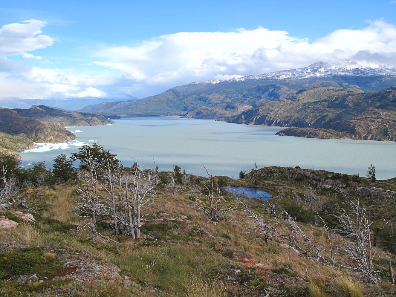 (Coming back from the glacier, the sun came out for a while, though it continually changed. Hiking up and down all of the hills, I almost got hot, but it simply took a minute or two of standing still to cool down with the fresh air and wind blowing. I wore a jacket at first, but I kept having to take it on and off, so I ended up without it most of the time. For almost the entire trek, I hiked with my hat and gloves in hand, as I would take them on and off over and over again as I got hot or cold.)
 (After my first long day of trekking, I got back to the refuge and decided to splurge on an expensive dinner - about $20. I had hiked about 25 km/15 miles, so I felt like I deserved it. It wasn't exactly clear whether or not you could get more, so I loaded up my plate with pasta, meat, salad, soup, bread, juice and even some jello. Not too bad, really.)
 (For day two, I packed up my bags and headed off from Paine Grande down by the side of Lake Nordenskjold. This is the view of the looming mountains all around as you hike along the base of them.)
 (Moving across from Paine Grande to the French Valley was a fairly flat, though windy, hike, so that was a nice break, especially since I was carrying my heavy bag packed with food, tent, sleeping bag and a few bits of clothing.)
 (French Valley sits in the center of the park, a narrow valley between the two clusters of mountains, topped by glaciers. When the clouds clear off, it's a really beautiful place.)
 (The swinging bridge at the base of French Valley, leading directly to the Italian camp. These international names refer to the spots used by expedition teams when first climbing these mountains. I left my big bag at the ranger's office and headed up into the valley for a 4 hour hike, hoping the weather would stay calm.)
 (Trudging over a field of huge rocks and steeply ascending under the shadow of the mountains and glaciers, the trail then makes its way back towards some forest, with the side of the Cuernos above. The multicolored rock is a result of a magma intrusion from an ancient lava flow.)
 (I was still smiling as the clouds mostly stayed above the mountains, revealing this beautiful mix of streams, forest, rocks and ice. On the way down, I wasn't as lucky, as rain and wind came in, though it was never quite a downpour.)
 (Another typical view of magical French Valley.)
 (I was advised that the valley can get pretty muddy at times, but I was lucky to find it mostly dry, winding in and out of the forest.)
 (Near the top of the valley, you get bits of these strange, wind-blown trees. Just past this point, I got to the top of the valley, just in time to see a big storm and dark clouds coming in, covering an amphitheater of mountains that close in the back of the valley. The trees provided a nice refuge as the clouds dropped in, sheltering me first from the snow flurries and then from the stronger rain that flew by on the strong winds moving down the valley.)
 (One or two trees were just beginning to turn orange/red. I imagine this valley would be truly spectacular in early to mid April, though you might also get some pretty cold weather.)
 (One final view of the massive glacier hanging on the West side of the valley. I wasn't sure if I'd take an easy day and stay at the Italian camp for the night or move on, but I got back with about 3 hours of daylight left, so I ignored my tired legs and decided to push on to the next campsite, Los Cuernos refuge.)
 (Beautiful Lake Nordenskjold showing some of its blue/green color. The middle portions of the W Trek follow alongside this lake for long portions of the walk.)
 (Two small portions of the trek even walk along the pretty pebble beach. It provides a great view of the lake, but the strong winds coming off the water, carrying large mists of water from the tops of the waves provide good incentive to keep moving. You can see the gusts, white with water, coming across the lake, so I tried to hurry from one tree to another to provide a bit of shelter. If you're not ready for it, some of the gusts are strong enough to push you off the trail.)
 (Predictably, Los Cuernos refuge sits right underneath the peaks of the same name, providing some great views when the weather allows. The site is also known for having quite a few mice scavenging for food, and I even found one in my tent just before going to sleep, so I had to chase him around and empty out my backpack where he was hiding before trying to sleep and hoping that he was the only one to infiltrate my sleeping area.)
 (A final view just before darkness was setting in. French Valley lies beyond the first ridge on the right, and the Paine Grande refuge and Lake Grey are just beyond the second set of ridges in the background, where I had begun that morning.)


