Making our way up, down and around some of the slightly sparsely wooded hills and mountains of the inland part of Northern Malawi, our cramped minibus headed back down towards the coast, offering nice views of the small villages lining the beaches along the Northern stretch of Lake Malawi. The next big police roadblock was actually my stop, getting off in a tiny village/crossroads called Chitimba. The town is simply a few hundred meters of shops along the main road heading North along the coast up to Tanzania, sitting at the crossroads of the dirt road leading back up to Livingstonia. The problem is that there is virtually no public transportation up the steep, windy 15 kilometer road leading from the coast (Chitimba) up to Livingstonia, perched on a sort of plateau overlooking the lake and valley below. After declining a few ridiculously expensive offers from pirate taxi drivers waiting at the junction, I met a nice young man who recommended a tiny wooden shack a few meters down for some food while I tried to make a decision. Ducking under the short wooden doorway, I walked into the tiny "restaurant" to find a dark room with one long picnic table and Rastafarian flags and articles covering the walls. Then a friendly, smiling dreadlocked man named Elijah appeared, and I was able to get a quick meal of rice, beans and beef stew while chatting with him for a while about the basics of his religious beliefs and his thoughts on the state of his country. About an hour later, I needed to make a decision, and Elijah mentioned that a few people before had left their luggage with him for a day or two, making the trek up to the top on foot. Trusting him, we took my large backpack and sleeping bag back into the back room of the restaurant behind a hanging reed wall used to separate the two rooms, revealing his bed and a few of his possessions, and I soon walked off towards the dirt road with my small backpack and just a few supplies for the night.
Knowing that the long walk would be hard and take about 3-3.5 hours, I hurried up the track, passing a few farms and tiny huts as the road began snaking upwards into the thick woodlands up the mountainside. Immediately starting off, I thought I caught a huge break, as a car came up the road, but it was packed full of German tourists, so there was absolutely no room for me to hitch a ride. At this point, it was already getting late in the afternoon, giving me just about 3 hours before sunset, so I trudged along in the hot sun, starting to sweat and hoping a ride would come along, though Elijah had told me that very few cars come up the road, particularly in the afternoon. Passing a series of spectacular views, the road winds up through 20 hairpin, switchback turns before finally flattening out (relatively) for the last few kilometers. As luck would have it, after about 45 minutes of walking hard through under the bright sun and wiping away sweat, I heard the rumbling of a large truck crunching over the dirt and rocks below, so I stopped at one of the turns and hoped for a ride. Though it appeared that it was just going to drive past, the driver stopped a little down the road, and I jumped in the back of the flatbed truck, along with about 20 locals and some bags. It was probably better than the alternative of walking, but the ride up in the back of the truck on the bumpy road was extremely painful, bouncing up and down at every bump and ridge, painfully coming back down, hitting either my arms, butt or back in the process. As my body began to ache, we finally passed the entrance to Manchewe Falls, and I happily paid my minuscule fare to the driver ($2 vs the $40 quoted by drivers at the bottom of the hill) and walked over to the waterfall. Dropping 130 meters (about 440 feet), the narrow falls appears out of the forest, dropping off the sheer escarpment into the valley below. I sat in awe of the falling water at a nice viewpoint for a while before heading back towards the top of the falls for a little exploration before the sun set.
I was told there was a tiny cave under the top tier of the waterfall (about a 30 foot drop), so I walked around until finding a tiny opening and trail down some steep rocks leading to a small cave only about 20 feet deep and 10 feet high, concealed behind the mist of the top of the waterfall. Walking behind the falls was a magical feeling, though the history of the place certainly isn't a cheery one. This was apparently one of the spots that the local people used as a hiding spot when slavers came into the area in the mid to late 1800s, hiding from their prospective captors behind the loud, scenic water falling just in front of them. It was a great spot, but I couldn't really get past the somber feeling as I imagined those cowering in this very spot a hundred years before me.
As it was getting dark, I started up the gradual incline to Livingstonia, hoping I'd make it before complete darkness set in. I passed by a few sets of smiling children, happy to say hello to me, as well as a group of middle aged men dancing to some music blaring from the tiny convenience store/concrete hut isolated along the dirt road. The walk from the falls to town took me longer than expected, so I had to use my flashlight to guide the way for the last 15 minutes, passing by a few tiny houses and possibly storefronts as I asked each of the locals I saw the way to my intended hotel. The village is quite spread out along the hilltop, so I had a hard time finding my spot, though I eventually met up with a nice young guy who was on his way home from a shift at the hospital and showed me the way to the Stone House, the only proper guesthouse in the town. This is also a historical building from 1903, serving as a house for some of the missionaries and early leaders of the country. I was able to share a small room in the historic, colonial style home with two Dutch travellers after a nice local meal of rice and nsima.
Livingstonia itself was created as a home for the missionaries in the region, perched high up on the hillside to potentially reduce the risk of malaria which had caused quite a few problems in the two previous Western settlements in Malawi. Named for the explorer David Livingstone who charted much of the region, the village has existed since the late 1800s, featuring some of the more prominent and historic buildings in the Western history of the country. In the morning, I walked around the place, finding it to just be a few long dirt roads with huge trees lining the way, interspersed with a few very basic shops, a large hospital and one of the six universities in Malawi. Nevertheless, the cooler weather and great views down to the lake below make it a very scenic place, and the laidback attitude also helped its cause. Even so, I had to get on my way, deciding that I'd just walk the 15 km back down the hill instead of trying to add to any of the huge bruises on my back and arms from bouncing around in the truck bed on the way up. The walk down was much more pleasant, allowing me to enjoy the views and talk with a few of the local children who were always anxious to pose for pictures. Three hours later, I was back at the crossroads of Chitimba, hoping that I'd find Elijah and my bags happily waiting for me. Just as I expected, I walked in the tiny restaurant and found him and a few friends chatting. I spent another hour with him talking about politics and religion, also finding an article from the Malawian newspaper on this wall about Rastafarianism, echoing what he had told me before, nearly word for word. (This was also helpful because I didn't understand every word of his English.)
As there is a roadblock in both directions, I simply waited with Elijah and his younger brother, Frank, until a bus came by, and I paid my small fare and hopped on, finding it to be the most uncrowded bus I had seen in the country, meaning that almost every seat was full, but no one was standing in the aisles, so I had a relatively comfortable ride back down the coast for the next few hours, chatting with a few young schoolchildren interested to talk to an American. Eventually the bus came to a stop, and the driver instructed me that it was my turn to get off, pointing me in the direction of the next town. Within a minute, I found a shared taxi (just a small Toyota) with a few people piled in, and we made our way to the small town of Rumphi, serving as the center of the region. Rumphi is situated between a few nice, small mountains, and the flora here started to change with a bit more rock outcrops and boulders dotting the hills, along with the dry trees and shrubs along the way. Though fairly scenic, the town itself is sort of a hectic one-road place with bike taxi, trucks and minibuses all vying for your business. I found a cheap, characterless concrete block hotel room for the night, and then the next morning was spent negotiating with a few of the local drivers, finally finding a shared truck to take me down the dusty road to Vwaza Marsh. Normally transport wouldn't be a huge problem, but it was Sunday, so very few trucks were heading off in that direction, meaning that I had to wait about three hours before catching my ride, thankful that I had a seat in the cab instead of having to bounce around in the back again.
 (In the upper tier of the huge Mangwere Falls, there was a scenic cave where you could walk behind the water. As pretty as it was, I felt a strange aura there, as this spot was used by locals to hide from slave traders coming in town to steal away captives about 150 years ago.)
(The 350 foot waterfall slides down the escarpment of the rift valley that runs a few miles back from the lake shore in this scenic area.)
 (The historic clock tower of Livingstonia, a city built as a mission named for David Livingstone who explored much of the region in the 1860s.)
 (The mission was originally in two other sites, though it moved to a higher elevation and slightly cooler climate after problems with malaria in the first two sites. Much of this city was built in the late 1800s and early 1900s.)
 (Livingstonia is just a collection of a few historic buildings and local shops strewn along a dirt road or two atop the plateau.)
 (A local businessman operating the sewing machine outside his tiny concrete shop, very typical of the shops I saw all throughout the country.)
 (Walking back down the 15 km, 3 hour walk to the lake shore, I found the local kids loved posing for pictures.)
 (These cute kids also asked for a picture to be taken, anxious to see themselves as I showed them my results on my camera.)
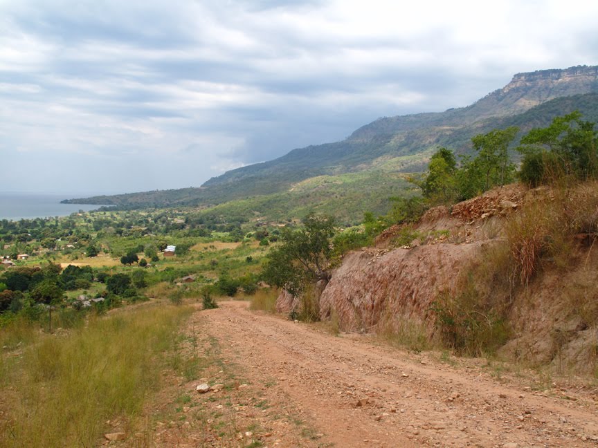 (The 15 km road is rocky and steep, featuring 21 bends, most of which are sharp, hairpin turns, winding its way from the high mountain above to the lake shore below. Fortunately, I caught a ride about halfway up. Unfortunately, it was another truck, and my back was badly bruised after that ride.)
 (Frank, me and Elijah. Elijah is an amazing Rastafarian who told me all about his religion, made some great beans and rice in his restaurant and also stored my bags for me for a day while I went up to Livingstonia. Frank, his brother, is also a nice guy and loves posing for pictures.)


0 comments:
Post a Comment